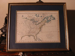
"A Correct Map of the United States of North America" published in 1787 by Thomas Bowen.
Entitled, A Correct Map of the United States of North America, this is an early hand-colored, copper plate engraving of a colored map of the United States, tinted to show the original 13 states. The map was published shortly after Independence and prior to the admission of Kentucky, Tennessee and Vermont as states.
A Correct Map of the United States of North America was published under Royal Authority in England by Thomas Bowen, and engraved for Bank's' New System of Universal geography. It was printed in England between 1787-1790. This map is noteworthy for being the first English map to acknowledge the former 13 colonies as an independent nation, the United States of North America, less than a year after the treaty of Paris, signed in 1783.
This map covers the original 13 American States, Louisiana, and parts of Canada, Florida, and Mexico. It shows the boundaries, towns and Cities, forts, Indian villages and tribal territories, mines, grasslands, geography of Indian tribes, prominent mountain ranges and relief, and a few historical notes. Both East and West Florida are depicted as well.
As the son of Emanuel Bowen, the official engraver for King George II, Thomas Bowen engraved for his father's atlas, British American Plantations, 1754. The younger Bowen went on the engrave for such geographical works as Captain Cook's Royal English Atlas, 1767; Atlas Anglicanus, 1761; Morant's Essex, 1768; Taylor and Skinner's Roads, 1776; Middleton's Geography, 1777-1778; Carver's New Universal Traveler, 1779; Hogg, 1785, and Forester's History of Voyages, 1786.
Provenance: Acquired by purchase.
ZFC Significant Flag
Item is Framed
Sources:
Bowen, Thomas, Correct Map of the United States of North America, 19 November 2011, from: http://www.marshall.edu/library/speccoll/virtual_museum/weaver/map11.asp
Emmanuel Bowen and Thomas Bowen, Cartographers, Mapcarte.com, 19 November 2011, from:
http://mapcarte.com/cartographers.html
Image Credits:
Zaricor Flag Collection


